Description
The Great Otway National Park stretches from Torquay through to Princetown and up through the Otways hinterland towards Colac. The park features rugged coastlines, sandy beaches, rock platforms and windswept heathland. In the north, the park features tall forests, ferny gullies, magnificent waterfalls and tranquil lakes.
Great Ocean Walk
There are some sections of the Great Ocean Walk that are accessible for visitors with mobility limitations and for families with strollers. These sections vary in level of difficulty and are dependent on the type of mobility equipment used. Visitors to the Great Ocean Walk are required to travel in an east to west direction.
Many sections of the Great Ocean Walk are unsuitable for wheelchairs and strollers due to steepness and the presence of many steps. Some sections of the walk are also unsuitable due to very loose beach sand, river crossings and intertidal zones.
The most accessible sections of the Great Ocean Walk are:
- Apollo Bay Visitor Information Centre to Marengo Caravan Park;
- Cape Otway Lighthouse car Park to Aire River Camp Ground;
- Gibson Steps to Twelve Apostles Visitor Centre.
Maits Rest
- The forest walk has sections of raised boardwalk, compacted soil and aggregate.
- Some steep sections lack handrails.
- There are excellent interpretive signs along the path.
- Vehicle access to this site is excellent, and the area around the car park is free of obstacles.
- There are no picnic or toilet facilities. The closest are at Apollo Bay or the Aire River Camping area.
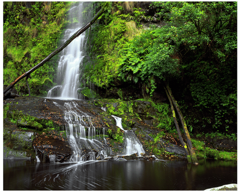
Blanket Leaf Picnic Area (and Erskine Falls)
- Blanket Leaf Picnic Area has accessible picnic tables, and some shelter.
- There are toilet facilities near the car park, though the designated accessible facility does not meet all access criteria.
- Erskine Falls is a short drive (approx 2km) from Blanket Leaf Picnic Area.
- There is a walk from the car park to the falls, but no facilities at this site.
- The path up to the falls viewing area is quite steep with uneven steps and a loose gravel surface.
Distillery Creek Picnic Area
- This accessibility information refers to the picnic area closest to the toilet facility, which is generally the more accessible of the two areas at Distillery Creek.
- The ground is generally flat but covered with leaf litter, and has some uneven surfaces.
- The accessible toilet across the road meets some access criteria.
- The Distillery Creek Nature Trail shows a diversity of plant life and is reasonably accessible.
Moggs Creek Picnic Area
- Moggs Creek Picnic Area is on reasonably flat ground in a natural setting.
- There are no formal paths around the site.
- The toilets are across the road from the picnic area.
- Access to the toilet is restricted by a narrow main door, but otherwise it meets many criteria for access.
- The Moggs Creek walking circuit leaves from the picnic area and takes about 30 minutes.
- There is a lookout bay on the Great Ocean Road near this picnic area.
Sheoak Falls carpark
- Sheoak Falls carpark has a good smooth surface and good circulation.
- The tracks nearby are not so accessible as they have steep sections and steps.
- There are no picnic facilities or toilets on site. The nearest facilities are in Lorne.
Sheoak Picnic Area
- Sheoak Picnic Area has good picnic facilities including gas barbecues.
- The surface is rough, and there are no formal paths.
- There is a designated accessible toilet facility that meets most criteria for access, although the approach is over a loose surface.
Detailed accessibility information
A detailed accessibility assessment was completed in 2014 of:
- Aire River West – day visitor area and campground
- Blanket Bay campground
- Cape Otway Lighthouse
- Johanna Beach – day visitor area and campground
- Shelly Beach
- Triplet falls
Gallery


There are no reviews yet.